- Home
- About Us
- Canvas
- Echo Tech
- Kids Enclosure
- Gallery
- Team
- E-Services
- Contact Us
GIS Based Mapping
Mapping Punjab's Forests with Advanced Geo-Spatial Technologies
Completion of GIS-Based Forest Boundary Level Digital Atlas
The Punjab Forest Department has made a significant step in forest management by completing the GIS-based forest boundary-level mapping of the entire province. This mapping effort, which employs advanced geo-spatial technologies, has culminated in the creation of a comprehensive Digital Atlas, providing crucial data on the distribution and types of forests throughout Punjab. The initiative not only aids in managing forest resources more efficiently but also plays an essential role in conservation and environmental protection.
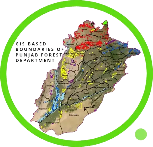
Role of GIS in Forest Management
The mapping process has provided detailed insights into the total area of Punjab’s forests. A total of 1,648,646.41 acres have been precisely mapped, offering a clear representation of how these forest resources are spread across the region.
Mapped Forest Types
| Sr No. | Forest Type | Total Area(Ac) | Mapped Area(Ac) |
|---|---|---|---|
| 1 | Irrigated | 440052.71 | 440052.71 |
| 2 | Riverine | 143343.33 | 143343.33 |
| 3 | Scrub | 679663 | 679663 |
| 4 | Coniferous | 113602 | 113602 |
| 5 | Coniferous/Scrub | 30410 | 30410 |
| 6 | Range Land | 241575.37 | 241575.37 |
Role of GIS in Forest Management
Geographic Information Systems (GIS) are transforming the way forests are monitored, managed, and conserved. By employing GIS technology, the Punjab Forest Department can now track forest boundaries and land use changes in real-time. This improves the ability to detect encroachment, deforestation, and other environmental issues, while also enhancing the management of forest-based resources. The GIS-based mapping offers a dynamic tool for forest management, enabling the Department to visualize changes in the landscape, monitor biodiversity, and make informed decisions on conservation strategies. Additionally, it plays a crucial role in disaster management, particularly in the wake of forest fires or floods, by helping authorities respond swiftly and effectively.
Implications for Conservation and Policy-making
The completion of this GIS-based mapping project is a milestone in Punjab's commitment to sustainable forest management. It not only ensures that natural resources are managed efficiently but also strengthens conservation efforts aimed at preserving Punjab’s biodiversity. By making the data publicly available, the Punjab Forest Department invites collaboration with environmental researchers, NGOs, and policymakers to protect vulnerable ecosystems. This mapping initiative is expected to drive policy decisions that promote environmental stewardship and sustainable land use, fostering a greener, healthier future for Punjab. Incorporating geo-spatial data into forest management systems also enables better planning for future conservation projects, habitat restoration, and the preservation of Punjab's rich natural heritage.